Pluton geology

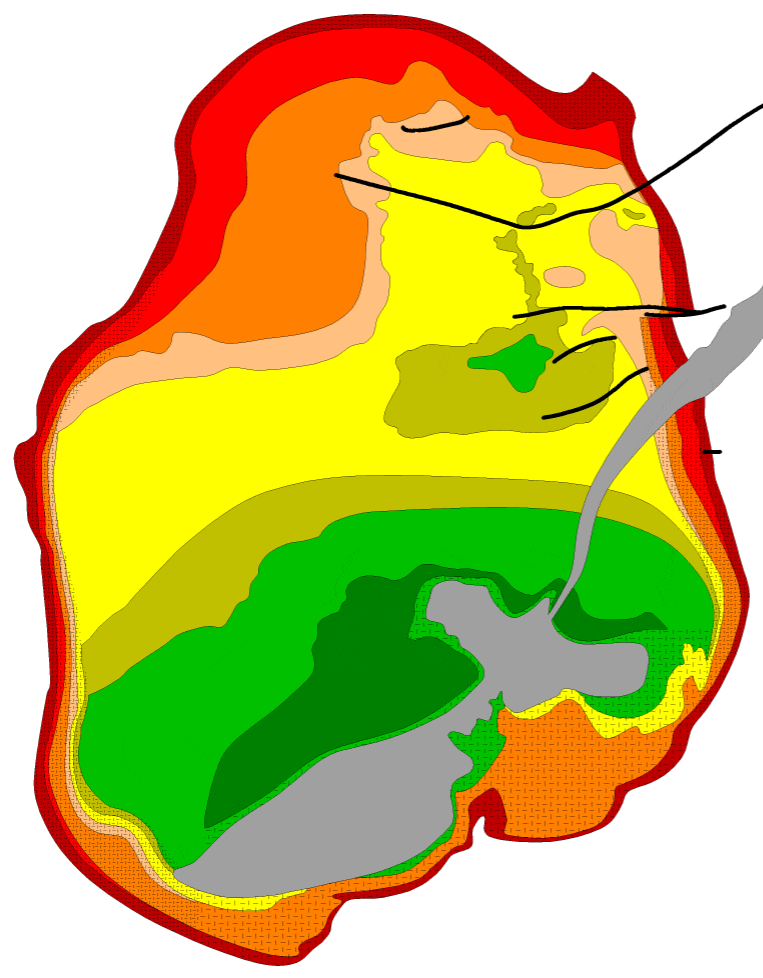
Geologic map of the Skaergaard intrusion, modified after McBirney (1989). The map unit explanation is shown below.
The dark blue lines are the field excursions on land, described in the daily trip pages.

Explanation for the geologic map. Unit names largely follow McBirney (1989). Links in the following list are to thin section micrographs.
UBZT: Upper Border Series T
UBZα: Upper Border Series alpha
UBZβ: Upper Border Series beta
UBZγ: Upper Border Series gamma
UZc: Upper Zone c
UZb: Upper Zone b
UZa: Upper Zone a
MZ: Middle Zone
LZc: Lower Zone c
LZb: Lower Zone b
LZa: Lower Zone a
HZ: Hidden Zone*
* The Hidden Zone is now thought to be of small volume, and similar to the upper border series T.
Steeply dipping Marginal Border Series (MBS) rocks on the pluton walls are shown with a fine pattern overlay, upper border zone rocks (UBZ) on the pluton roof are shown with a coarse pattern overlay. The upward thinning of LZa, LZc, and UZa, and their absence from the Upper Border Series, is modified after the original schematic of McBirney (1989), though it seems realistic that their equivalents also occur in the Upper Border Series. They were doubtless difficult to map in the tremendously rugged terrain where they are exposed. Plag = plagioclase; Ol = olivine; Pig = pigeonite; Aug = augite; Fe-Aug = ferroaugite; Fe-Bust = ferrobustamite; Mt = magnetite; Ap = apatite.
My interpretation of the Skaergaard layering beneath water, ice, and unconsolidated material. Colors, pattern scheme, and scale are identical to the map above. The Basistoppen sheet is shown connected to the Vandfaldsdalen macrodike that extends northeastward from the sheet, as suggested by the color scheme in McBirney (1989) and as interpreted by the field trip leaders. My apologies for poor transcription or idiotic misinterpretations.
References
- Andersen, J.C.Ø., Rasmussen, H., Nielsen, T.F.D., and Rønsbo, J.G., 1998, The Triple Group and the Platinova gold and palladium reefs in the Skaergaard intrusion: stratigraphic and petrographic relations: Economic Geology, v. 93, p. 488-509.
- Blank, H. R., and Gettings, M.E., 1973, Subsurface Form and Extent of the Skaergaard Intrusion, East Greenland: Eos, v. 54, no. 4, p. 507.
- Brooks, K., 1997, The Skaergaard intrusion: sixty years of petrological research: Compiled by Brooks, K., Danish Lithosphere Centre and Institute of Petrology, University of Copenhagen.171 p.
- Holness, M.B., Nielsen, T.F.D., and Tegner, C., 2017, The Skaergaard Intrusion of East Greenland: Paradigms, Problems, and New Perspectives. Elements, v. 13, no. 6, p. 391-396.
- Irvine, T.N., 1992, Emplacement of the Skaergaard Intrusion: Carnegie Institution of Washington Year Book, v. 91, p. 91-96.
- Irvine, N.T., Andersen, J.C.Ø., and Brooks, C.K., 1998, Included blocks (and blocks within blocks) in the Skaergaard intrusion: geologic relations and the origins of rhythmic modally graded layers: Geological Society of America Bulletin, v. 110, p. 1398-1447.
- Irvine, N.T., Andersen, J.C.Ø., and Brooks, C.K., 2001, Excursion guide to the Skaergaard intrusion, Kangerdlugssuaq area, east Greenland, Volume 1: Text:. International Geological Correlation Project 427. Sponsor: Camborne School of Mines.
- Irvine, N.T., Andersen, J.C.Ø., and Brooks, C.K., 2001, Excursion guide to the Skaergaard intrusion, Kangerdlugssuaq area, east Greenland, Volume 2: Plates and Figures: International Geological Correlation Project 427. Sponsor: Camborne School of Mines.
- McBirney, A.R., 1989, Geological map of the Skaergaard intrusion, east Greenland, 1:20,000: Department of Geology, University of Oregon, 1 sheet.
- Topographic map, 1975, Skaergården, Kangerdlugssuaq region, east Greenland, 1:20,000: Geodætisk Institut, Copenhagen, Denmark.
Related web sites
- The Virtual Skaergaard Intrusion: J.C. Andersen
- Field research
- Paper on mineral crystallization, alteration, and melting
- Geochemical Thermometry of the Layered Series Rocks of the Skaergaard Intrusion
Note about the imagery
All field photos were taken with an old Pentax MX SLR camera with a 50 mm f1.7 lens, and ASA 200 Kodacolor film. Add-on close-up lenses were used in some cases. The 35 mm negatives were scanned at a resolution of 50 pixels/mm. The raw scans were processed to produce the mostly 700 by 500 pixel images presented here. Graininess, seen in numerous images, is the result of underexposure caused by a failing shutter. Sorry about that.