Enormous numbers of basaltic dikes crosscut the Skaergaard pluton and surrounding rocks. They occur in many different orientations, and they range from centimeter-thick dikelets, through dikes of normal size, to enormous “macrodikes” more than 100 m across. All of the dikes that cut the Skaergaard intrusion are, of course, younger than the pluton itself. Dikes that fed the Tertiary basalt lavas into which the Skaergaard intruded must be older, and so only occur in the surroundings. The Skaergaard therefore straddles the age of the numerous dikes in the area. Dikes are much more numerous and widespread than are indicated in the McBirney (1989) geologic map.
Dikes of normal size
Normal dikes are typically ~0.2-10 m across and occur in the thousands, cutting the Skaergaard pluton and the surrounding Archean gneisses.

A thin basaltic dike cutting graded layering within a 250 m long autolith block on Kraemer Island.

Looking east along a 5 m thick plagioclase-rich dike in the Homestead area (dike labeled “1” in Irvine et al., 1998, just off their Figure 5 to the upper right). This dike is tied with the Campsite composite dike (below) for the oldest dike in the homestead area. Unfortunately the area with the required crosscutting relationships to break the tie is covered. This dike is unusual, containing abundant, large plagioclase phenocrysts in its more central portions. The dike has a chilled margin, with only sparse plagioclase phenocrysts, suggesting that the first batch of magma into this dike did not have so many. Notice the thin chilled margin, and some contact-parallel layering in the lower middle part of the picture.

The central portion of the plagioclase-rich dike in the photo above. Many phenocrysts are acicular and in radiating bunches.

Looking southeast along the 4 m thick, xenolith-rich Campsite composite dike, in the homestead area (dike is labeled “2” in Figure 5 of Irvine et al., 1998, this photo and my samples are from near label “A” in that figure). This dike is tied with the plagioclase-rich dike (above) for the oldest dike in the homestead area, because the area with the required crosscutting relationships is covered. This dike is unusual, containing ~30% xenoliths of sizes ranging from centimeters to meters. The xenoliths are mostly gabbros, containing plagioclase and mafic minerals that are more An-rich and Mg-rich, respectively, than any found in the exposed Skaergaard Layered Series. They may be from the Skaergaard hidden zone, but if so geochemical modeling demands a much larger hidden zone than gravity modeling suggests. Gravity modeling suggests very little hidden zone, and what there is of it is probably like UBZT and MBST.

Stuck for the day in the small fjord on the southwest side of Kraemer Island. The northwest side of this fjord, shown here, has Archean gneisses cut by numerous basalt dikes of many widths and orientations.

Splays at the end of a basalt dike cutting the giant gabbro autolith on the east end of Kraemer Island, adjacent to Uttental Sund. The en echelon continuation of this dike is visible in the upper left (gray rather than brown), which ends a few meters beyond the photo to the lower left.

A basaltic dike cutting LZb on Kraemer Island, which unusually contains numerous xenoliths of Archean gneiss. View is approximately to the east toward Uttental Sund, barely visible at the upper left.
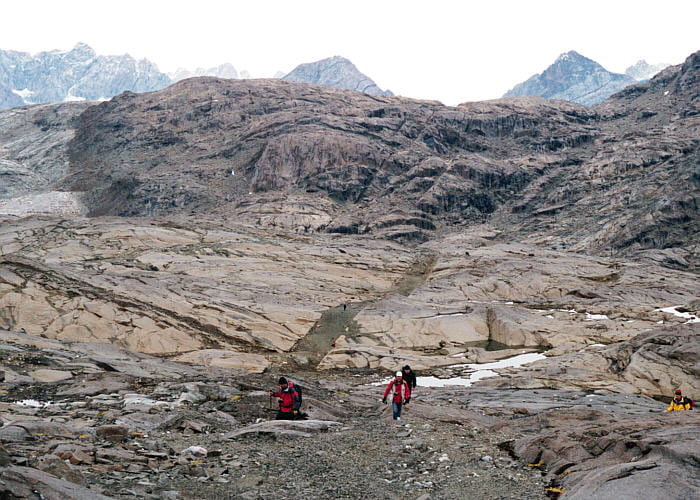
One of the so-called “tramway dikes,” wide basaltic dikes of great length that traverse the Skaergaard and surrounding gneisses, particularly on the western side of the pluton. This one has been broken up into gravel that makes a surprisingly smooth, flat roadbed. View is to the north, with the rise in the background being the Uttental Plateau. The western contact of the Skaergaard is visible in the upper left, with gray gneisses against dark-brown Skeargaard gneisses. The mountains in the distance are on the other side of Watkins Fjord.
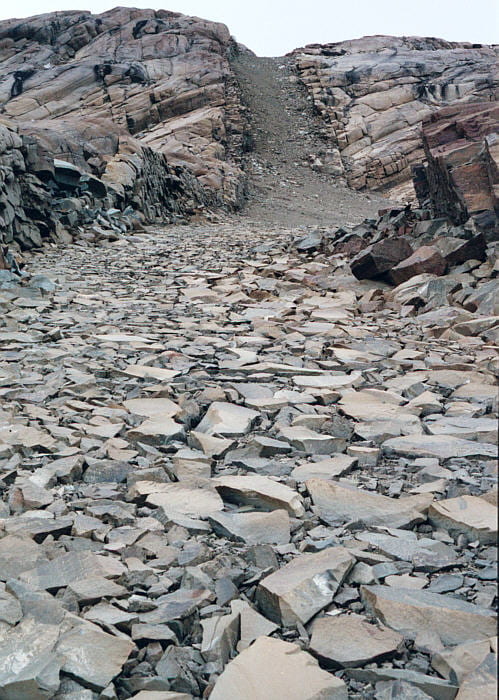
A 10 m wide dike with a remarkably smooth, flat, road-like surface made by oriented basaltic rocks. View is to the west.
What made the broken blocks rotate, so their flat surfaces are almost uniformly upward, is so far out of my area of expertise that I can’t even begin to speculate.
Macrodikes
These are dikes of enormous size, 100 m or more thick, and are difficult to photograph from the ground, especially when it is evening and raining. The Basistoppen sheet was probably emplaced by a macrodike that extends northeast from Douglas Plateau. The photos below are of the Mikis Fjord macrodike. These macrodikes, at least, are coarse-grained and internally layered. A major problem of macrodikes is how they can be emplaced as single units.

View to the southwest, down the outcrop surface of the macrodike, with the ship beyond. The macrodike extends approximately straight ahead, on this photo, across the fjord. However, the macrodike is not seen again in this direction, and does not show up on the other side of the fjord. It is either terminated along a syn-emplacement fault, or it takes a dogleg to the left and runs along the fjord floor out to sea.

Close-up of the macrodike interior rock, showing large plagioclase and pyroxene crystals. This area has a lot more vegetation than any place on the Skaergaard, and it was hard to find a place to photograph where there was no moss or lichen.