In the Skaergaard region, there are numerous small valley glaciers and ice fields. We saw some large valley glaciers in the distance, but the central Greenland icecap was too far inland to see from any vantage point I visited. All of the rocks we visited were once covered by moving glacial ice, as recently as the early Holocene.
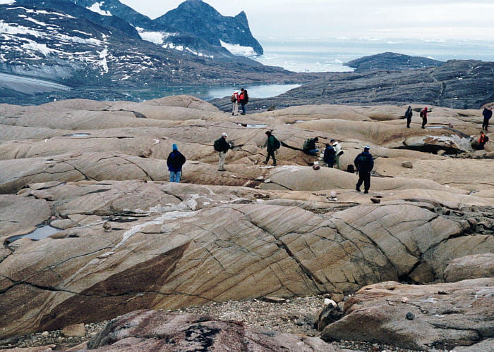
Glacially smoothed rock surfaces occur in the foreground, and on all more distant regions. Weathering has removed the glacial polish from most places, but glacial striations still remain. In general, only a millimeter or two has been removed by post-glacial weathering. The sloping toe of Forbindelses Glacier can be seen in the upper-left.

View to the north from the Homestead region toward Wager’s Top, the highest peak visible (1277 m). Three glacial snouts are visible, which from left to right are Hænge Glacier, Bjørneskinds Glacier, and Forbindelses Glacier. As I understand it, all of the small valley glaciers in the Skaergaard region reached the water when the area was first studied by R.L. Wager, in the late 1930’s. Now, few or none reach the sea.

This our only view to the north of the Skaergaard pluton, toward the Greenland interior. The interior icecap is not visible, but you can see in the distance the merging of two large valley glaciers, that then empty into Watkins Fjord.
The calving face of the glacier is in the distance, highlighted by exposed blue ice. The fjord surface is almost completely covered with icebergs and sea ice. The glacial tongues in the foreground are the Dobbelt Glaciers.

View from the flank of Basistoppen to the southwest across the toe of Basis Glacier, on the margin of Skaergaard Bay. Beyond the glacier toe is our ship, and Kangerlussuaq Bay in the distance

View south from the flank of Basistoppen, looking across Basis Glacier to a small glacial tributary coming down off of Sydtoppen (1058 m). Tinden (1044 m) is the peak to the right, in the distance. Notice that some of the Basis Glacier surface still has relatively new snow and ice, whereas the darker surface has been ablated and has lots of rock debris discoloring the surface.

View east from the flank of Basistoppen to the head of Basis Glacier, above which is Basis Pass and the Douglas Plateau (an ice plateau). Our walk went down to the glacier and then up and over the pass.

View to the southeast from Basis Pass, showing the upper part of the Douglas Plateau, above an ice cliff.

Looking northwest from the Douglas Plateau, with arcuate crevasses visible where the Douglas Plateau ice cascades down between Nunatak 1 (off the photo to the right) and Basistoppen (the steep slopes in the center and left) to Forbindelses Glacier. In the middle distance on the right is Pukugagryggen, and in the far distance are mountains on the other side of Watkins Fjord.

A small crevasse on the Douglas Plateau.

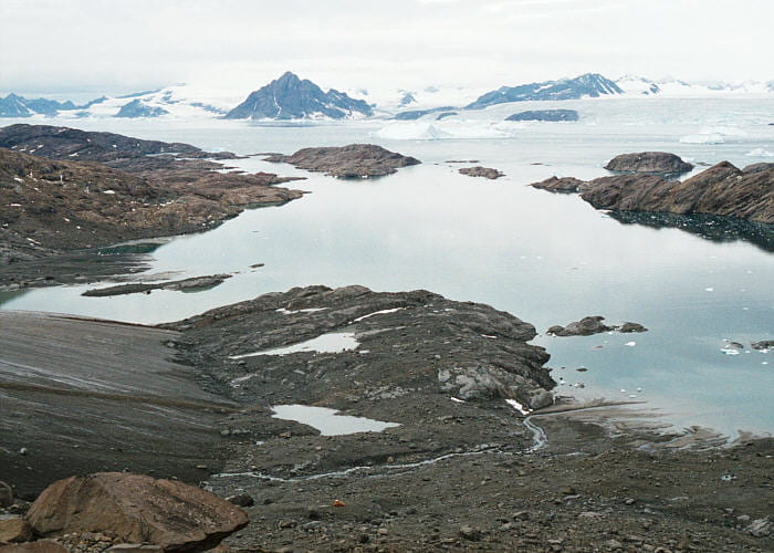
Looking northwest from the Douglas Plateau, with the Forbindelses Glacier far below. Pukugagryggen is on the right, Uttental Sund in center left, left of which is Kramer Island. The Uttental Plateau and the western contact of the Skaergaard intrusion is visible in the center distance. Mountains on the other side of Watkins Fjord in the far distance. This image shows very well the barren landscape and relatively smooth, crunchy ice surface.

View to the west from Nunatak 1. Forbindelses Glacier is below, as is Uttental Sund, beyond which is Kramer Island. The western contact of the Skaergaard against Archean gneisses is visible just above and to the left of center.

View to the northeast from Nunatak 1, looking over the saddle at the top of Forbindelses Glacier. Beyond the saddle, the glacier spills down toward Mikis Fjord, to the left into the distance, but does not come very close to the water (see next photo). The north end of Nunatak 2 is visible on the right. Layered Tertiary basalts are visible in the distance.

View to the west from Mikis Fjord with Forbindelses Glacier visible up toward the saddle. Notice the classic U-shape to this glacial valley. This is the northern end of Mikis Fjord, though it extends farther to the east behind me. The small pile of stones in the near ground is a pre-Inuit house that was abandoned 3000 to 4000 years ago. Skins would have covered the stone foundation.

Looking west across the crevasse field where Douglas Plateau ice cascades down to Forbindelses Glacier between Nunatak 1 (left) and Nunatak 2 (behind me). Pukugagryggen is the slope on the right, and Kramer Island is most of the rock in the distance.

Looking north across the flat surface of Forbindelses Glacier toward Pukugagryggen. The surface of this glacier had few crevasses of any size. Because of the warm day and bright sunshine, the whole surface was melting. Small trickles and streams covered most of the crunchy ice surface.

View to the southeast from the top of Forbinelses Glacier toward Nunatak 2 in the middle ground, and Kilen (931 m) in the distance, with Douglass Plateau extending up to the right.

View west down the rough, crunchy surface of Forbindelses Glacier across Kangerlussuaq Bay. The islands are at the entrance to Uttental Sund.

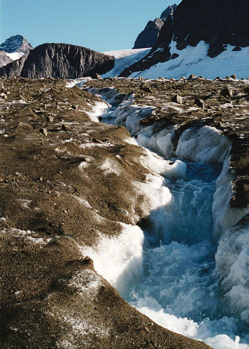
Meltwater stream on the surface of Forbindelses Glacier. The glacier surface had many such streams, though this is one of the largest at this elevation. View is to the east, with the rocks to the upper right being Nunatak 2.

Rushing meltwater stream coming down off the flank of Forbindelses Glacier, looking east toward Nunatak 2.

View to the east from the prominent lateral moraine on the north side of Forbindelses Glacier. Pukugagryggen is on the left, with the MZ exposed on its base and the UZa above. The moraine material is composed of mud, sand, cobbles, and boulders. Some has melted out from within the ice, and some has fallen down from the adjacent cliffs. The light grayish-brown loose material to the left of the glacier, against the red-brown rock, is a lateral moraine produced when the glacial ice was somewhat thicker.
Rushing meltwater stream cutting through the medial moraine on the north side of Forbindelses Glacier. The cliff at the top left is Nunatak 1, the slopes to the right are Basistoppen, and between is the Douglas Plateau.

Meltwater stream in the photo above plunges to the base of the glacier here, to exit the glacier at the outwash plain near Uttental Sund.

View to the south from the north side of the toe of Forbindelses Glacier. Subglacial meltwater streams can be seen exiting from the glacier base at the bottom of the photo.
Another view looking from a higher elevation onto the toe of Forbindelses Glacier. Notice how dirty the glacial ice is. This is caused by the fact that, as the ice melts, much of the entrained rock, gravel, sand, and mud remain in place to accumulate on the surface. The biggest meltwater stream exiting from the base of the glacier is obvious here, as is the outwash delta in Uttental Sund. In the 1930’s the outcrops below center were under glacial ice.

Looking east across Uttental Sund from Kramer Island toward Forbindelses Glacier. Nunataks 1 and 2 are the cliffs in the top-center, Basistoppen is the large mass, with a big snowfield, to the upper right.

Photo from the Zodiac looking east up Basis Glacier toward Basis Pass, and Douglas Plateau barely visible beyond the pass. Basistoppen is on the left and Brødretoppen is on the right. The larger ice fields on Basistoppen and Brødretoppen do flow and so are glaciers in their own right. This perspective gives some idea of the thickness of ice once needed to bury this entire glacial landscape. The current glaciers are grimy shadows of their former selves
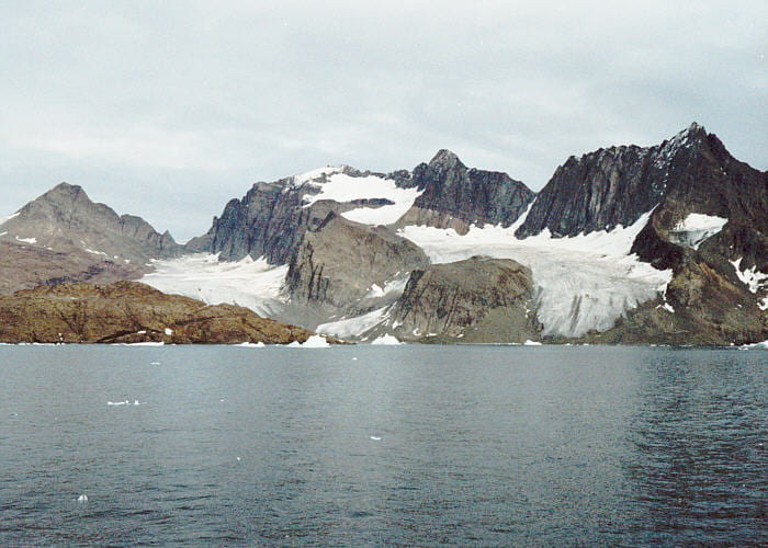
View to the northeast from the ship. From left to right are Basistoppen, Basis Glacier, Brødretoppen, Brødre Glacier, and Tinden. Both of the glaciers end above sea level.