This was the longest walk we had on this trip, and the only substantial walk on glaciers. We were lucky enough to have a brilliantly clear, relatively warm day, and mild winds.

Early morning view southwest across Skaergaard Bay, with the Skaergaard Peninsula in the middle ground, the Homestead area is to the right, and Kangerlussuaq Bay is in the distance.

Looking west from higher up, with Kramer Island in the distance. In the middle ground is Uttental Sund, with Mellemø, Lille Mellemø, and Lille Ivnarmiut Islands visible at its entrance on the left. The Homestead Area is in the foreground.

Looking uphill at a waterfall and a basaltic dike to its left. This is on the way up toward Basistoppen. Here we are in unit UZb, but on the plateau above we’ll be in unit UZc.

A large, laterally extensive mafic pegmatite in UZc, extending off into the distance. It is not clear to me that this pegmatite is a replacement, like so many others seen in lower units. It looks more like a sill. UZc is scarcely layered at all, unlike the units lower down, so it is difficult to tell if it is layer-parallel or crosscuttig.
A close-up of part of the mafic pegmatite in the photo above. Note that the interior of this pegmatite contains abundant granophyre (fine-grained, light-gray material), in addition to the usual coarse-grained gabbroic minerals. Magnetite is black, pyroxene and olivine are rusty, and large plagioclase crystals are mostly white.
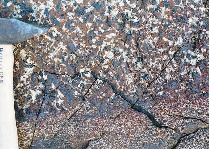
Close-up of the margin of the same mafic pegmatite as the above two images, showing massive mafic pegmatite and the contact with host UZc gabbro. A small angular notch in the contact suggests, though does not prove, an intrusive relationship.

View to the southwest, across Skaergaard Bay and Kangerlussuaq Bay beyond. Our ship is visible to the left of the nearest five sizable icebergs.

Photo looking southeast across Basis Glacier, to a small glacial tributary coming down off of Sydtoppen (off the photo to the top left, 1058 m).

Basistoppen summit (885 m), photographed from a minor summit at 504 m, just west of Basistoppen. Our traverse will take us around the right side of the summit cone.

View to the west from the 504 m lesser summit, across Skaergaard Bay (lower-left), the entrance to Uttental Sund (right), and Kangerlussuaq Bay (beyond the foreground rocks).

View to the southwest, with the ship visible at the entrance to Skaergaard Bay. The toe of Basis Glacier is visible on the left. Our ship is visible almost exactly in the photo center. Here is an image combining this photo and the one immediately above.

View to the north toward Wagers Top (right, 1277 m) from one of the Platinova drill hole sites. The rubble pile on the right is a moraine from the small glacier on the northwest flank of Basistoppen.

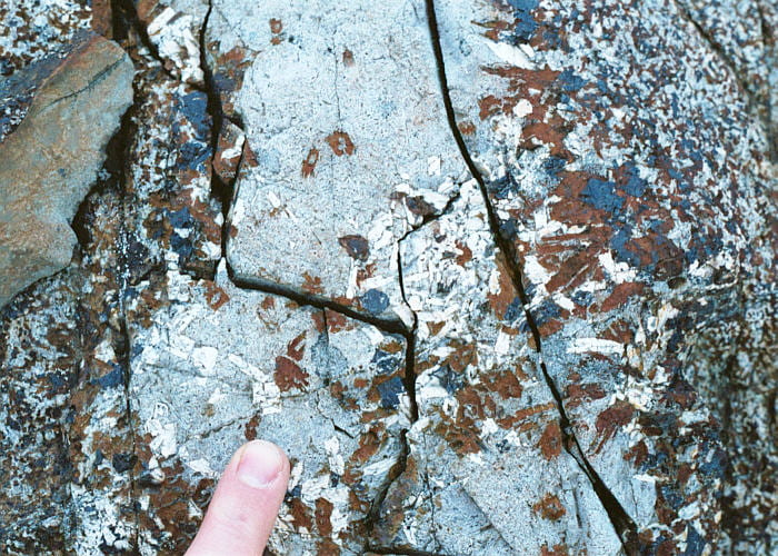
Possible sandwich horizon locality 1 on the southwest flank of Basistoppen. The sandwich horizon is the surface along which floor and roof rock finally met, during the final stages of pluton solidification. All three trip leaders said the sandwich horizon was difficult to find in the field. Trip leaders Kent Brooks and Neil Irvine thought that this small outcrop was about as close to being the sandwich horizon as they had ever seen.
By the way, the rifle is for polar bears. If they meats ya, they’s gonna eat’s ya.
Close-up view of part of the sandwich horizon candidate 1 outcrop. The sandwich horizon is supposed to have up to 1500 ppm Zr. My thin section of this outcrop had no visible zircon, though it did have a lot of granophyric material and apatite.

View from the southwest flank of Basistoppen, looking east to the head of Basis Glacier and Basis Pass. The ice beyond the pass is the Douglas Plateau. Our walk goes down to the glacier and over the pass. The way up to the pass was on boulder moraine at its angle of repose (it was no fun at all). The Basistoppen sheet is above the break in slope on the left, and occupies all of the wall on the right.

View to the southeast across the toe of Basis Glacier, and across the entrance to Skaergaard Bay. Our ship and and Kangerlussuaq Bay beyond are visible.

View down onto Basis Glacier, looking southeast from the southwest flank of Basistoppen. Except for the dark lowermost part, all of the wall is made of the Basistoppen sheet. Notice the internal layering in the Basistoppen sheet.

View to the west from Basis Pass. The brown south flank of Basistoppen is in the bottom-center, which is the Skaergaard UZc and perhaps includes the sandwich horizon along its upper part. The ice is the Basis Glacier. The gray rocks on the right are of the Basistoppen sheet.

View to the southeast from Basis Pass, showing the upper part of the Douglas Plateau ice sheet, above the near-ground ice cliff. The rocks are of the Basistoppen sheet, in which some faint layering is visible.

Just beyond Basis Pass, but also just below the Douglas Plateau. Pukugagryggen (1104 m) is visible to the north, above the rim of ice.

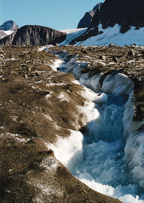
Drinking from a glacier meltwater stream, just below the Douglas Plateau.
My guess is that the wind really whistles through this hollow in the ice in the winter.

Walking up a snow ridge to get to the Douglas Plateau. View is to the southwest. Essentially all of the rocks visible are of the Basistoppen sheet.

A small crevasse on the Douglas Plateau.

Looking northeast from the Douglas Plateau. Pukugagryggen is to the left, Gabbrofjeld in the center distance, and Gabbro Glacier in center-right. The knob to the lower right is Nunatak 1.

Looking northwest from the Douglas Plateau, with crevasses visible where the Douglas Plateau ice cascades down to Forbindelses Glacier between Nunatak 1 and Basistoppen. The slope on the left is Basistoppen, with the gray, shattered rocks above being the Basistoppen sheet, and the brown rocks lower down being Skaergaard UBZγ. In the middle distance on the right is Pukugagryggen, and in the far distance are mountains on the other side of Watkins Fjord.

Looking northwest from the Douglas Plateau, with the Forbindelses Glacier far below. Pukugagryggen is on the right, Uttental Sund in center left, left of which is Kramer Island. The Uttental Plateau and the western contact of the Skaergaard intrusion are visible in the center distance: brown Skaergaard against light-gray Archean gneiss. The most distant mountains are on the other side of Watkins Fjord.

View to the west from Nunatak 1. Forbindelses Glacier is below, as is Uttental Sund, beyond which is Kramer Island, on which the western contact occurs, where brown Skaergaard rocks is against gray Archean gneiss beyond.

View to the northeast from Nunatak 1, looking over the saddle of Forbindelses Glacier. Beyond the saddle the glacier spills down the other side toward Mikis Fjord. The north end of Nunatak 2 is visible on the extreme center-right.

View to the northeast from Nunatak 1 looking at the merger of Gabbro Glacier and Forbindelses Glacier. Behind Gabbro Glacier is Gabbrofjeld.

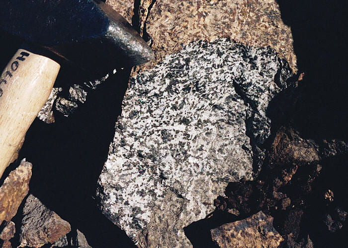
Felsic clots in UBZγ. To a metamorphic petrologist they look like boudins, though the matrix rock does not look at all deformed. It is not clear to me if these felsic clots are replacement anorthosite, deformed autoliths, deformed layers, or injected material.

Close-up of UBZγ on top of Nunatak 1, on part of the outcrop in the photo above. White plagioclase, black magnetite, and rusty olivine and pyroxene are visible.

Irregular mafic clots in UBZγ on top of Nunatak 1. As with the felsic clots shown two photos above, it is not clear to me how these formed. They don’t look like xenoliths, autoliths, deformed layers, or injected material, and may be a replacement.

Jens Andersen deemed this outcrop, on the middle eastern flank of Nunatak 1, to be his best candidate for the sandwich horizon. The texture of this rock is essentially isotropic. Gabbrofjeld is in the distance to the northeast.

Close-up of the isotropic rock in this sandwich horizon candidate, in the photos above. The brown spots are altered olivine (masses of talc, serpentine, and magnetite) and the rest is a mixture of augite, plagioclase, and opaques. Quite a mess in thin section.

Looking southwest, upward from Forbindelses Glacier, up the east flank of Nunatak 1. The gray rock in the middle and left is part of the Vandfaldsdalen macrodike, which probably fed the Basistoppen sheet. The dike contrasts with the reddish-brown Skaergaard rocks to the upper right.

Looking west across the crevasse field where Douglas Plateau ice cascades down to Forbindelses Glacier, between Nunatak 1 and Nunatak 2. Nunatak 1 is the rock mass on the left, Pukugagryggen is the slope on the right, and Kramer Island is most of the rock in the distance.

Looking northeast across the upper part of Forbindelses Glacier, with Gabbro Glacier up to the left.

Looking north across Forbindelses Glacier toward Pukugagryggen.

View to the southeast toward Nunatak 2 in the foreground and Kilen (931 m) behind it.

View to the southeast toward Nunatak 2 in the foreground, with Kilen (931 m) behind.

View west down Forbindelses Glacier across Kangerlussuaq Bay. The mouth of Uttental Sund is visible, with several islands in it, the largest of which is Mellemø.

Rushing meltwater stream coming down off the top of Forbindelses Glacier, looking east toward Nunatak 2. The top of the glacier is dirty just about everywhere. I suppose that’s from dust blowing off the surrounding rocky areas. As the ice melts, the dust accumulates on the surface.

View to the east along the prominent lateral moraine on the north side of Forbindelses Glacier. Pukugagryggen is on the left, with the MZ exposed on its base (triple group in there somewhere) and the UZa above.
Rushing meltwater stream, cutting through rocky debris on the north side of Forbindelses Glacier. The cliff at the top left is Nunatak 1, the slopes to the right are Basistoppen, and between is the Douglas Plateau.

Meltwater stream in the photo above plunging down to the base of the glacier. The stream exits the glacier at the outwash delta, near Uttental Sund, seen below.

Abandoned bulldozer and sledge, just north of the toe of Forbindelses Glacier. This was landed by several small plane loads on the glacier, assembled, and driven down to help with a drill team. It turned out not to be of much help, and was abandoned here.

View to the south, from the vicinity of the bulldozer, overlooking the toe of Forbindelses Glacier. Subglacial meltwater streams, like the one heading down the hole in the photo three above, can be seen exiting from the glacier base.


Photo from the landing area where the Zodiacs picked us up. View is to the northeast, with the western end of Pukugagryggen on the right, Bjørneskinds Glacier, and Wager’s Peak in the distance. The Triple Group can be seen on both slopes (tic marks), as can two large autoliths including the largest known autolith below Wager’s Top. Put your cursor over the image to see markers showing where the Triple Group, the macrorhythmic layering section (M), and some of the autoliths (A) are labeled (press left or right buttons).


View from the Zodiac, looking east up Basis Glacier. Basistoppen is on the left and Brødretoppen is on the right. The upper part of Basistoppen is made of the Basistoppen sheet, which dips to the right (south) such that the whole dark gray wall on the right (south) side of Basis Glacier is made of the Basistoppen sheet. The contact above the Basistoppen sheet on Brødretoppen can be seen as a transition from dark gray below to lighter brownish above, which is UBZγ. Pur your cursos over the image to see where the Basistoppen sheet is located. Press left or right buttons to see the labels.
